Intro:
Cozia mountains are located in the Eastern Carpathians (or Romanian Carpathians), in the center-west part of Romania being part of Southern Romanian Carpathians. On a road map, they are located nearest the E81 european road, between Ramnicu-Valcea and Sibiu cities, at the entry of the so called The Olt Valley, nearest the Cozia Monastery, at about 25km of Ramnicu-Valcea and 70km of Sibiu.
The highest peak from Cozia Mountains is Cozia Peak (alt. 1668m); the main route is the Cozia Chalet route, which was also my destination.

Route map
About this 1-day track:
It starts from Turnu Monastery (alt. 250m) and climbs to the "La Troita" springs on the red-band marker; here the track meets 2 other markers: the blue-band (from Pausa village) and the yellow-band (from the Cozia Dam); all 3 tracks continue together to a point where the red-band, that I further followed, turns to left and climbs over the "Muchia Traznita" Heights to the "Turneanu" shelter; from here the red-band turns to right over the "Turneanu" Heights and passes beside the "Pietrele Vulturilor" (Eagle Stones), the "Rotunda" Peak (1593m) and "Cozia" Peak (1668m); the red-band track arrives to "Cozia Chalet" (alt. 1573m) and "Cozia Relay" (located on "Ciuha Mica" Peak, 1629m). A beautiful view of The Olt Valley (to the South-West) is available here.
Elevation Curve: From the Turnu Monastery until the "Cozia" Relay, the track is a medium to hard one, practically the altitude difference is of about 1300m on a distance of aprox 6-6.5km which may be followed in about 4-6 hours, depending of various conditions.
*
From the "Cozia Relay", the red-band marker is lost (track finishes there), and the blue-band is followed; the blue-band descends via the "Muchia Vladesei" Heights to the "Stanisoara" Monastery; the track is a hard one, as it passes through massive rocks; 2 portions of the track present chains that are helpful for the tourists; some little caves may be seen beside the track and also the "Fruntea Oii" Heights; the track arrives at Stanisoara Monastery, a beautiful monastery, at an altitude of about 750m. Here a little time may be lost, as there are some objectives to see: a waterfall, 2 caves, aso. The blue-band meets again the yellow-band and further the red-band described above while the track descends to "La Troita" Springs. From here, the red-band is followed to the right, back to the Turnu Monastery.Elevation Curve: From the "Cozia" Relay back to Turnu Monastery, the track is a medium to difficult one (the part from Cozia Relay to Stanisoara Monastery is difficult), practically the altitude difference is of about 1300m on a distance of aprox 6.5-7km which may be followed in about 2-4 hours, as the track descends, depending of various conditions.

Elevation Curve for both portions (Google Maps)
*
The route follows the next objectives:
- "Turnu" Monastery;
- "La Troita" Springs;
- "Muchia Traznita" Heights;
- "Turneanu" Shelter;
- "Turneanu" Heights with "Rotunda" Peak;
- "Cozia" Peak;
- "Cozia" Chalet with "Cozia" Relay;
- "Muchia Vladesei" Heights;
- "Stanisoara" Monastery;
*
Here are some images from the route:

View to Cozia Relay from "La Troita" - Muchia Traznita Heights
View to The Olt Valley from "La Melita"

Shelter nearest the "Muchia Scortaru"

Heights nearest "La Melita"

Turnu Monastery zoomed from "La Melita"

The Olt Valley from Turneanu Heights

Turneanu Heights

Turneanu Heights - view to Cozia Peak

Path to Cozia Chalet

Cozia Chalet and Relay

The Salvamont (mountain rescue) lodge at Cozia

Cozia Relay

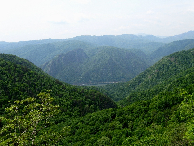
The Olt Valley

"Muchia Fruntea Oii" Heights

Various markers on the way down to Stanisoara (blue-band is the good one)

View to "Fruntea Oii" Heights

Heights beside the track

Curious tree on the track

Traditional fountain at Stanisoara

Stanisoara Monastery

Turnu Monastery
*
*
No comments:
Post a Comment