Romania, Ciucas Mountains, Beautiful Mountain Routes
A quick intro may be useful...
The Easter Holidays came and together with some friends decided to follow a mountain route in the Ciucas Mountains.
Ciucas Mountains are located in the Eastern Carpathians (or Romanian Carpathians), in the center of Romania, nearest the area named Curvature of Carpathians that unifies the Eastern Romanian Carpathians with the Southern Romanian Carpathians. On a road map, they are located beside the DN1A national road, between Ploiesti and Brasov cities, at about 70km of Ploiesti and 35km of Brasov.
The highest peak from Ciucas Mountains is Ciucas Peak (alt. 1954m); there are several mountain routes, each one with its unique profile and interesting touristic objectives.
We accomodated at Cheia mountain resort (alt. 900m) and we decided to follow 2 routes in 2 consecutive days.
*
Day One route:
Cheia (alt. 900m) - Muntele Rosu Chalet (alt. 1280m) - Ciucas Chalet (alt. 1595m) - "Tigaile Mari" (Large Pans, alt. 1840m), approx 20km (way and back to Cheia ~8 hours),
we chosen to follow the route on map below:

As the arrows say, we followed the blue circle marker on the map, then the yellow bar,
then we returned to Cheia resort by passing "Valea Berii" (Beer Valley) by following the blue cross marker.
 Elevation Curve for Day One (Google Maps)
The Ciucas Chalet burned about 2-3 years ago... It was a small chalet before the fire, so we decided to see the brand new chalet which is still under construction.
Here are some images from that route:

 The seismological station at Muntele Rosu resort
 The Salvamont (Mountain Rescue) Chalet at Muntele Rosu resort

 ... and chalet from the front

... and Large Pans and Ciucas Peak

The "Gropsoarele" Heights (1883m) and "La Rascruce" (Routes Crosspoint, 1805m),
which we passed a day after
(zoom from Ciucas Chalet)

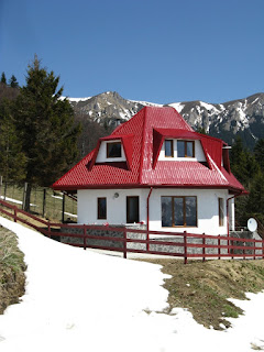
A traditional house on the "Valea Berii" Beer Valley
at our return from that route
*
Day Two route:
then we returned to Cheia resort by passing "Valea Berii" (Beer Valley) by following the blue cross marker.

The Ciucas Chalet burned about 2-3 years ago... It was a small chalet before the fire, so we decided to see the brand new chalet which is still under construction.
Between the objectives, I may count:
- "Muntele Rosu" Chalet and Resort (1280m);
- "Ciucas" Chalet (1595m);
- "Chirusca" Peak (1664m);
- base of "Tigaile Mari" Heights (1720m);
- "Valea Berii" (Beer Valley);
- "Cheile Cheitei" (Cheitei Gorge).

Muntele Rosu Chalet


Ciucas Chalet (1595m) and "Tigaile Mari" (The Large Pans) Heights


... and Large Pans and Ciucas Peak

The "Gropsoarele" Heights (1883m) and "La Rascruce" (Routes Crosspoint, 1805m),
which we passed a day after
(zoom from Ciucas Chalet)

A traditional house on the "Valea Berii" Beer Valley
at our return from that route
*
Day Two route:
Cheia (alt. 900m) - Muntele Rosu Chalet (alt. 1280m) - Gropsoarele Heights (alt. 1883m) - Zaganu Heights (alt. 1817m) - Zaganu Sheepfold, approx 14km (way and back to Cheia ~8 hours);
we chosen to follow the route on the map below:

Gropsoarele and Zaganu Heights mountain route map
Practically, as the arrows say, the route follows a blue circle marker, then a red triangle,
then a red cross, then a mixed red cross with blue bar.
This was a more spectacular route than the one we did a day before, as it has many objectives and panoramic views and it also was a little more difficult as we passes some heights and peaks.

Elevation Curve for Day Two (Google Maps)
Between the objectives, I may count:
- "Muntele Rosu" Chalet and Resort (1280m);
- old ski track "Muntele Rosu";
- "Muntele Rosu" Saddle (1650m);
- "Muntele Rosu" Peak (1765m);
- "La Rascruce" mountain routes Crosspoint (1805m);
- "Culmea Gropsoarelor" Heights;
- "Gropsoarele" Peak (1883m);
- "La Lanturi" Chained Pass or "Podul de Arama" Copper Bridge;
- "Zaganu" Peak (1817);
- "Peretele Alexandru" Stone Wall;
- "Peretele Alexandru" Stone Wall;
- "Stana Zaganu" Sheepfold.
Below are images taken from this route:

Overall view of Gropsoarele Heights and Zaganu Peak

Muntele Rosu Chalet, a closer view


The old ski track of Muntele Rosu resort

Path to Muntele Rosu Peak

View to Cheia from Muntele Rosu Saddle

Muntele Rosu Saddle - view from Muntele Rosu Peak
*
We remembered the route a day before and we took some images in that direction:

View to Ciucas Chalet (1595m) and "Babele la sfat" (Old Women Counsel) Ciucas Heights

View to Ciucas Heights

Zoom to Ciucas Chalet, Large Pans and Ciucas Peak
*

Back to Gropsoarele and Zaganu Heights

The 2 shelters (ex- seismic probes) on North of Gropsoarele Heights

View to Muntele Rosu Chalet from Gropsoarele Heights

View to Cheia resort from Gropsoarele Heights

Gropsoarele Heights

Gropsoarele Heights - view to Zaganu Peak

Gropsoarele Peak - view to Ciucas Peak

On the way to Zaganu Peak

View to "Piatra Vulturilor" (Eagle Stone)

View to "Culmea Stancoasa" (Rocky Saddle) and "Piatra Vulturilor"

Zaganu Heights - View to Cheia

Zaganu Heights - Before Zaganu Peak

Zaganu Heights

Passing Zaganu Peak

Passing Zaganu Peak

Eastern Ciucas mountains - view from Zaganu

Zaganu Heights - After Zaganu Peak

Zaganu Heights

Zaganu - view from South

Zaganu Heights - A 1782m peak at top of Alexander Wall

"Stana Zaganu" Sheepfold
*
great post, very usefull, and these maps help a lot
ReplyDeleteWell, I tried to make a useful briefing.
ReplyDelete