Short briefing
The Belgrade Fortress, also known as Kalemegdan, is located in the north part of Belgrade - capital of Serbia, at the confluence of Rivers Sava and Danube.
Judging by the remains discovered on the site, the fortress was established in the Neolithic period on the plateau occupied by the present Upper Town, or Acropolis. Then, this settlement became a Roman Empire part, a castrum called Singidunum (the oldest known name for Belgrade).
The fortress was located at the border between austrians and ottomans, so, along the time, it was held by both parts.
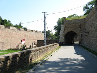
The fortress we see today was built in mid-18th century, but its walls encircle the old 15th century Acropolis or the Upper Town, that were built when Belgrade was proclaimed for the Serbian capital in 1404. Then, at the last Ottoman occupation around 1750, Belgrade Fortress was given its final form, preserved until today.
Kalemegdan was declared Monument of Culture of Exceptional Importance in 1979.
*
Images:
South Walls
South Walls
South Walls
Main Gate and Clock Tower
Clock Tower
Artillery Museum at the Clock Tower
cannon at the Clock Tower
ruins in the north-east side
ruins in the north-east side
Danube - view from Kalemegdan North
Despot Stephan Tower
Zindan Gate and Towers
The Victor - Protector of Belgrade
North Walls
Orientation Competition in Kalemegdan
Orientation Competition in Kalemegdan
West Side and view to Kalemegdan Park
Kalemegdan miniature
through the gate
View to Sava river
Kalemegdan Park
View to the West side and The Victor
West Side
Kalemegdan Park
Inside Walls
Inside Walls


No comments:
Post a Comment